GeoJSON Export
- ID: geojson-export
- Author: Diogo Moreira
- Contact: df.moreira@campus.fct.unl.pt
- Current Version: 1.2.1
- Summary: This extension allows the export of an AIGP's POSA and the layers of a scenario version (POSP, Transformation Units, Ecosystem Services) in GeoJSON format.
Functionality
The extension can be accessed via the extensions menu on the scenario editing page (top right corner, puzzle icon > GeoJSON Export).
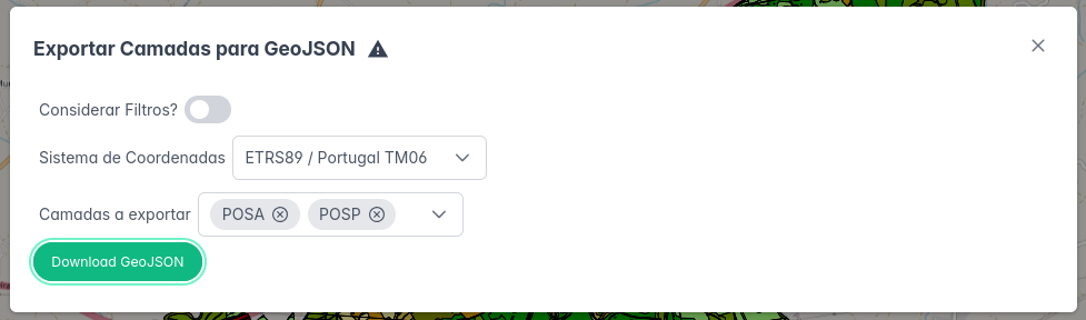
The export options are as follows:
- Consider Filters?: When active, only the geometries currently visible according to the user's active filters are exported.
- Coordinate System: The reference system to be used for the export.
- WGS84: Global reference system.
- ETRS89/Portugal TM06: Official reference system for Mainland Portugal.
- Layers to Export: Selection of which layers (POSA, POSP, Transformation Units, Ecosystem Services) to export.
After defining these options, clicking the "Download GeoJSON" button will generate and download a ZIP file containing one GeoJSON file for each exported layer.
Changelog
- 1.2.1
- Bug fixes
- 1.2.0
- Added the ability to choose the coordinate system (WGS84 or ETRS89/Portugal TM06)
- 1.1.0
- Extension interface improvements
- Bug fixes
- 1.0.0
- Initial version of the extension